


When we hear the word navigation we think of using a Global Positioning System (gps) to travel from one location to another. For photographers venturing into the untrammeled wilderness to capture unique photos, skilled use of a gps and map are essential. But there is another form of navigation of greater importance to photographers—finding good light. Not only do we want to know when the sun will rise and set so we can shoot during the golden hour, but we also want to know where it will rise and set.
For familiar locations—like where we live—we rely on readily available astronomical data to tell us when it will rise and set, and experience to tell us how the path of the sun varies from season to season. Popular photographic destinations, like national parks, are by now well documented so it is just a matter of some internet searching to determine time of year/location for the best light. A classic example is called Firefall at Yosemite National Park. In the second week of February the setting sun hits Horsetail Fall at the right angle such that it glows orange and red. [It has become so popular that this year the Park Service has restricted access.]. But what about locations that we are unfamiliar with or are not that well documented? How do we predict the light to get the best from our photographic outings?
In this digital and computational age there is a wide variety of smart phone, tablet, and computer apps from which to navigate the light. The author does not profess a comprehensive knowledge of the subject and is only providing a summary of those apps he has used. They range from simple to sophisticated/elegant to downright magical. Recommendations for others are welcome.
Simple – Sun Seeker
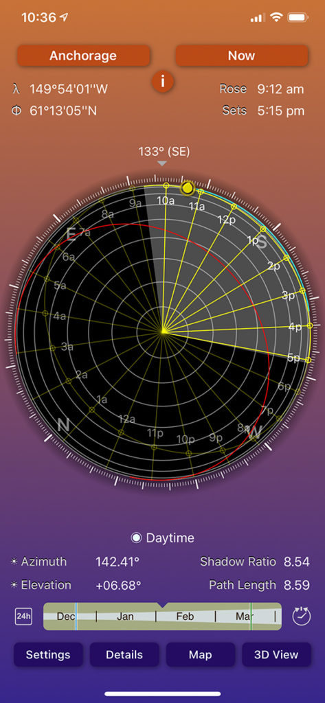
For $10 this smart phone app provides sun rising and setting times based on your current location/date or can be set to any known location/date in its database. The path of the sun and its elevation above the horizon is overlaid on a compass. [Sun Seeker also does have an Augmented Reality overlay which we will discuss in another app.] Orienting your smartphone horizontally and pointing it in the direction of the sun will give you an idea of the sun’s prior and future path where you are. When I took this screen shot (Figure 1) of the app on my phone this morning, I could see where the sun would set later this afternoon. While it has a map layout, I don’t use it for finding the light for new and unfamiliar locations. I like maps on larger platforms with topographical features with which to navigate the sun.
By the way, a sister app called Moon Seeker performs similarly for the moon with the addition of moon phases.
Sophisticated – Photographer’s Ephemeris
The most robust and sophisticated app which predates most others is Photographer’s Ephemeris. Ephemeris is an astronomical term which describes the tabular locations of celestial bodies at prescribed times. Photographer’s Ephemeris is available for free as a web app for computers, or for $10 as an app on the iPhones/Android platforms or on tablets. I prefer it on a tablet or larger to best use the map-based layout.
Figure 2 shows the web app layout on a desktop computer. My home location is designated by a red pin on the topographical-style map. Below the map is information on the sunrise/sunset as well as moonrise/moonset. Just below that is a timeline allowing you to drag a slider to adjust the time of the day. The thick yellow line delineates the sun’s direction at sunrise while the orange line that of its sunset. The thin yellow line moves with the timeline slider to show the bearing of the sun at the current time. In addition to heading the slider shows the elevation of the sun above the horizon. When the sun drops below 6º above the horizon a 6º yellow shadow circle appears. This indicates when shadow lengths are greatest and approximating the time for golden hour. Photographers seek golden hour for some of the softest and warmest sun of the day. By having this sun information overlaid on the topography of the land I know exactly where the sun will be and what land features will be illuminated in the foreground/background. So for today’s date I can look in the direction of the mountains indicated to see where the sun will rise. However, I don’t know when it will rise above a particular mountain summit. Fortunately, Photographer’s Ephemeris can handle that as well.
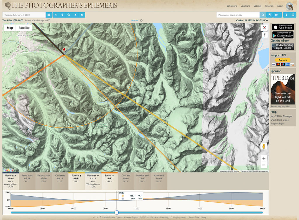
This capability in Photographer’s Ephemeris is known as geodesy, or geodetics. Knowing the ellipsoid (or squashed sphere) shape of the earth and some sophisticated mathematics, the distance, bearing, and apparent altitude between any two points on a map can be calculated.
In Figure 3 a grey pin has been placed southeast of the red pin at the top of a mountain across from Eagle River Valley that can be seen from my house. The distance and elevation difference of the grey pin from my home location, as well as the heading are shown in a box at the lower left of the map. But the most important piece of information is the apparent altitude of the mountaintop in degrees above the horizon, in this case 9.44 degrees. To the right of that is the elevation of the sun at that same heading at 15:05 (3:05 p.m.) which is 9.42 degrees. In other words, just after 3 p.m. on the afternoon of February 4, 2020 the sun should set just below that particular summit. Indeed, that is exactly what happened!

Elegant – Google Earth
Using satellite imagery Google Earth has mapped practically the entire earth’s surface to an amazing degree of detail. This includes Alaska, although some sections lack geographic detail and resolution. Fortunately, these sections are being filled in with time. To supplement the satellite imagery, Google is photographing the earth from street level to provide map apps with an intimate real world perspective for navigating. The street level views are now combined with the satellite imagery in Google Earth to project a 3D view of our earth from practically any location. I was even surprised to find that Google’s “photographing car” had at some time come up our mountainside switchbacks to map my home location.
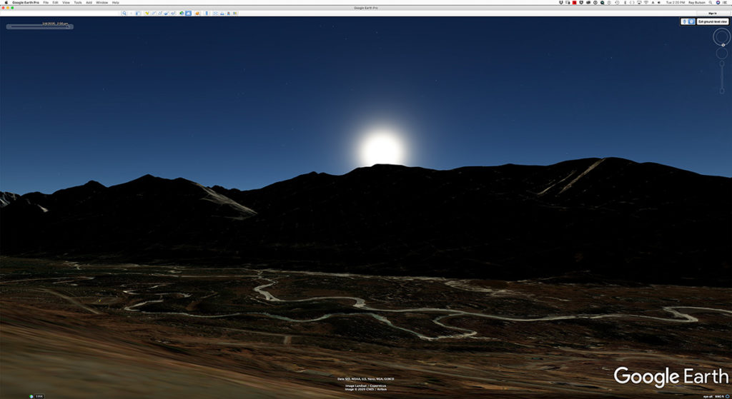
Figure 4 shows the Chugach Mountains ridgeline from close to my house with the location of the sun at 2 p.m. on February 4, 2020. This is very close to what I observed firsthand today and very cool! While it lacks the data that Photographer’s Ephemeris provides I suspect this visual approach appeals to many photographers. Photographer’s Ephemeris also has a 3D version which does something similar to Google Earth.
Magical – Augmented Reality and PhotoPills
Augmented Reality (AR) uses a smart phone or tablet’s camera to superimpose live imagery onto an apps graphical framework. In the case of the sun, its path is superimposed onto the particular sector of the sky shown by the phone/tablet’s camera in real time. PhotoPills ($19.99 phone/tablet) is not the first to implement AR, however, if there is one app to buy for photography this is the one since it does so much more than just sun times/locations.
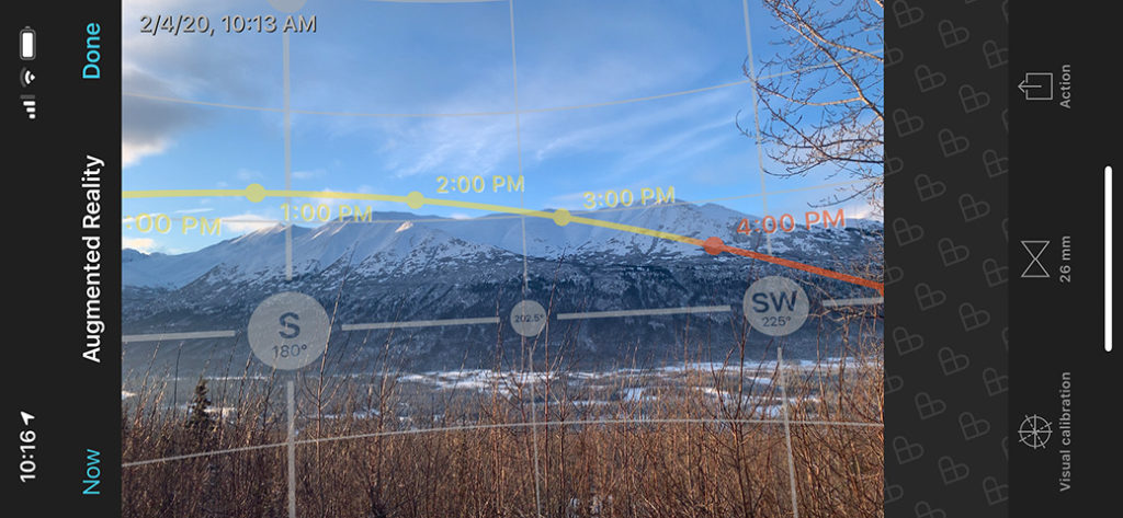
Figure 5 shows the projected path of the sun over the Chugach Mountains across from my house. It was photographed at 10:13 this morning so I was interested to see where the sun was at 2 p.m. vs. what PhotoPills predicted. Using a different camera to photograph the sun, Figure 6, shows how close the prediction was. Also note PhotoPIlls AR prediction for when the sun drops below the summit of the mountain ridge is just before 3 p.m. Given the errors of me pinpointing the exact location of the peak using Photographer’s Ephemeris, I think this result is quite amazing.
Another app which uses AR, and might be of interest especially to astrophotographers, is Sky Guide ($2.99). I use it locate the Milky Way with my phone and to identify constellations in real time.

With the wealth of accurate information these sun navigation apps provide, photographers can confidently research and plan the best vantage points, seasons, and times of day to photograph new locations. This may mean getting a starburst shot just as the sun rises above a particular mountain, or warm, soft low light sweeping across the landscape at the right angle. As a landscape photographer, knowledge of the lay of the land and how the sun illuminates it makes field work more predictable and enjoyable. Now if only we had this kind of foresight and control over the weather!